March 2006
Volume 04, Issue
10
March 2006 |
|||||
Volume 04, Issue
10 |
|||||
| Integrated Defense Systems |
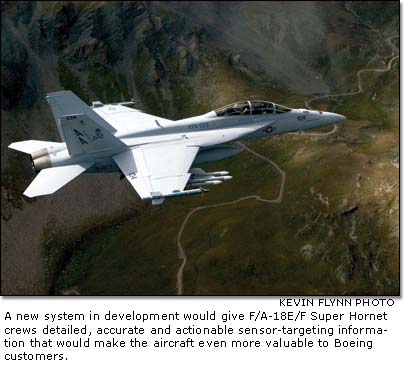
| Image-ine that New Super Hornet system aims to provide faster, more accurate target locations BY KATHLEEN COOK
That isn't exactly what sensor imagery exploitation is, but the technology Boeing has pulled together will take existing systems from the customer, Boeing, suppliers and even the U.S. National Geospatial-Intelligence Agency (NGA) to produce sensor-targeting information that is extremely detailed, accurate and ready to act on. And the work that produces these images will be done not by the pilot, but by the computer aboard an F/A-18E/F Super Hornetmaking an already formidable aircraft even more valuable for Boeing customers. "Historically, in an aircraft, a sensor provides a tactical image on a screen in the cockpit, and the pilot manually exploits (extracts warfighting information from) the displayed imagery," said Chris La Fata of Boeing, who is part of the team that began working on this more than four years ago. "Our goal is to teach the onboard computers to automatically exploit that image for the pilot." The computer produces information faster than a human can do the same calculations, with improved accuracy. The idea for this system grew from a U.S. Navy planning "road map" goal to automatically produce target coordinates from satellite imagery and reduce pilot workload. A team from Boeing, which included the Advanced Platforms Systems thrust and the F/A-18 New Product Development groups, took that future Navy requirement and, using Boeing funds, began designing a system to meet it. The system compares what onboard sensors are detecting with an NGA "library" of satellite images. Once the images are matched, the pilot or weapon systems officer can mark the image on the cockpit screen to indicate a particular stationary target, such as an armory or bunker. That marked imagecomplete with GPS-compatible target location datacan be sent to ground troops for verification, to another aircraft or directly to the targeting system of one of the aircraft's weapons. And all of this takes just a few seconds.
"Once we get this system in the aircraft, the crew will be able to get more-accurate target coordinates at a much greater range," La Fata said. This in turn will increase the aircraft's standoff ranges, making the Super Hornet more lethal and more survivable. The team conducted fixed-target testing of the system in Boeing's test aircraft, F/A-18F1, in 2004. As successful as the fixed-target testing has been, La Fata said they will continue to refine the system. This spring, the team will conduct moving-target testing in the test aircraft using infrared imagery from an Advanced Targeting Forward-Looking Infrared sensor. The team is working with a moving target detector developed by a team from Science Applications International Corporation. This moving target detector work is related to the Mission Specific Processor, Defense Advanced Research Projects Agency program supported by Boeing's Integrated Missile Defense Systems. The moving target detection reports are processed by a multiple hypothesis tracker developed by BAE Systems. This tracker technology was initially evaluated and recommended by a team from the Boeing Network-Centric Operations thrust in Phantom Works. The tracker develops several possible patterns so if a moving object goes out of sight (such as when a truck goes behind a building) it can quickly reacquire the target by selecting the most likely movement pattern, then searching for the object in that area. The system looks for patterns that match the known image before it was lost from sight, then confirms the identification of the object and continues to track it. The Confirmatory ID capability is being developed by the Boeing Lasers and Electro-Optic Systems team. The technology demonstration version of the system will be integrated and prepared for flight evaluation by the Phantom Works Electronics Prototyping and Integration Center. The initial production system with a fixed-target capability could be ready to go into production aircraft beginning in late 2008. The team is not stopping there, however. La Fata said the team is developing a system that can allow the aircraft to track and target moving objects using Raytheon's Active Electronically Scanned Array radar imagery. Ultimately, the team would like to be able to identify "no hit" zones on the NGA images, such as schools or hospitals, and "blue forces" zones where friendly ground troops are located. The system would then be able to disengage a weapon if that weapon was going to hit a target within one of these zones. "So if a truck (being targeted) gets too close to a hospital, for instance, the system would direct the weapon to divert and defuse itself," La Fata said. Sound like something out of "Star Wars"? Maybe. But for the engineers involved in imagery exploitation, it's just another day at the office.
|
| Contact Us | Site Map| Site Terms | Privacy | Copyright | ||||||
| Copyright© Boeing. All rights reserved. |
 It sounds like a plot from a science fiction movie: Take a contraption you've created, meld it with someone else's invention, tweak the object to do something new, andvoila, you've created something magical.