June 2006
Volume 05, Issue 2
June 2006 |
|||||
Volume 05, Issue 2 |
|||||
| Integrated Defense Systems |
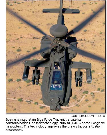
| Know thy enemy—and friend Communication by satellite gives Apaches information sharing at the speed of light BY LISA DUNBAR
The new technology, named Blue Force Tracking, is helping Apache Longbow pilots display and report enemy locations, display and identify friendly positions, and stay connected in a vast communications network. Although the Army informally began using Blue Force Tracking during 2003, Boeing signed a contract in 2004 to integrate the software into all future Apache Longbows, said Dewey Webb, program manager for the Apache Multi-Year II Digitization program. The technology uses a satellite communications system installed on the aircraft and connected to a joint network to send data and monitor status of other tactical platforms on the network. Unlike traditional line-of-sight radio communication, mountains and the earth's curvature are not obstacles to the helicopter's satellite-communications signal path.
The information travels at the speed of light, going from the aircraft to a satellite to a ground station, then is routed back to a satellite, then to the receiver for display to the crew. Not only are friendly and enemy positions displayed, but digital messages can be transmitted and received among platforms participating in the network. The system also has the ability to include free-text messages and automatically compose observation reports, using information contained in the aircraft's processors, to report enemy locations and information on neutrals in the area, Webb said. The information received over Blue Force Tracking is integrated into the aircraft's Tactical Situation Display and onto the digital map displays. This greatly improves crew tactical situation awareness. In fact, in Iraq, Apache pilots use the technology to keep connected to networks on the ground, report their aircraft's position and stay aware of the tactical situation on the ground. "The technology makes the Apache interoperable with other platforms so pilots can know where other helicopters are, where people on the ground are and where other friendly vehicle systems are," Webb said.
|
| Contact Us | Site Map| Site Terms | Privacy | Copyright | ||||||
| Copyright© Boeing. All rights reserved. |
 What
started as a commercial technology to track packages is now giving U.S.
Army pilots of Boeing-built AH-64D Apache Longbow helicopters communications
advantages in times of war and peace.
What
started as a commercial technology to track packages is now giving U.S.
Army pilots of Boeing-built AH-64D Apache Longbow helicopters communications
advantages in times of war and peace.